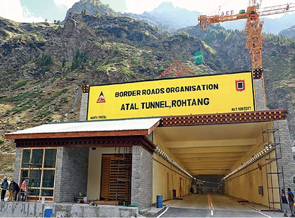
All-Weather Route to Leh Opened
The Atal Rohtang tunnel, named after former prime minister Atal Bihari Vajpayee, has been completed. To be opened on 3 October, it will ensure uninterrupted traffic between Manali and Leh throughout the year. Prime Minister Narendra Modi renamed the Rohtang Tunnel to Atal Tunnel, in honor of Atal Vajpayee, on 25 December 2019, Vajpayee’s birthday.
Strategic Connectivity
The Leh–Manali Highway, one of the two routes to Ladakh will now also be used to resupply the military garrison there. The other route into Ladakh is through the Zojila Pass on the Srinagar-Drass-Kargil-Leh highway, which also gets blocked by snow for nearly four months in a year.
The Rohtang Pass receives heavy snowfall and blizzards during winter months and is open for road traffic for only four months in a year. The tunnel will keep the highway open during the winter.
The tunnel connects Manali in Kullu district to Lahaul-Spiti district. Thanks to it, movement of goods to and from Lahaul will be easy.
The Rohtang tunnel, completed at a cost of about Rs 3,200 crore, is crucial at a time when there are border issues with China in Ladakh. The tunnel will allow mobility of defence forces in case of a prolonged standoff.
Construction of a 14 km long tunnel under Zoji La pass has been planned. These two routes are vital to feed military supplies into military sub-sector in the west facing Aksai Chin and the Siachen Glacier.
Specifications
The tunnel is 10 metres wide, 8.8 km-long and shaped like a horse shoe. The tunnel is at an elevation of 3,100 metres (10,171 ft) whereas the Rohtang Pass is at an elevation of 3,978 metres (13,051 ft). The nearest in comparison to the Rohtang Tunnel would be the Anzob Tunnel in Tajikistan (length 5 km, altitude 3,372 metres), Salang Tunnel in the Hindu Kush mountains in Afghanistan (length 2.6 km, altitude 3,400m) and the Eisenhower–Johnson Memorial Tunnel in the United States (length 2.73 km, altitude 3,401m).
Usually, it takes around five hours to cross the Rohtang Pass, but thanks to this tunnel, the journey will be shortened to just ten minutes. The Manali-Led road is now shortened by 46 km.
There are fire hydrants at every 60 metres, emergency exit tunnels at every 500 metres, turning cavern every 2.2km and air quality monitoring every 1km, Besides the emergency telephone booths at regular intervals, there is a broadcasting system and automatic incident detection system with CCTV cameras every 250 metres. The tunnel is being supplied with 11KVA of electricity to power equipment.
The 4G internet network inside the tunnel works well. Unlike other tunnels, where travellers lose mobile network, this tunnel provides uninterrupted BSNL mobile network with high-speed internet connectivity.
With a maximum speed of 80kmph, the tunnel is expected to see traffic of 3,000 cars and 1,500 trucks a day.
Challenges in Construction
The most challenging task was to continue the excavation during heavy snowfall in winter. Excavation for tunnelling was done from both ends. However, as Rohtang pass closes during the winter, the north portal was not accessible during winter and the excavation was being done only from the south portal in winters. Only about one-fourth of the entire tunnel was excavated from the north end and three-fourths was excavated from the south end. There were more than 46 avalanche sites on approaches to the tunnel.
Other challenges to the progress of the tunnel included difficulties in disposing more than 800,000 m³ of excavated rock and soil, heavy ingress of water (as much as 3 million litres per day in June 2012) that required constant dewatering, costlier treatment and slowed the progress of excavation from 5-metre per day to just half a metre a day and unstable rocks that slowed blasting and digging.
Four Years Delay
The foundation stone of the tunnel was laid on June 28, 2010. The tunnel was completed in a span of 10 years against the original estimate time of six years. The tunnel was conceived by the Indira Gandhi government in 1983. But it was much later in 2002 that the Vajpayee government declared a tunnel would be constructed. The project began to move only in September 2009. Construction began in June 2010.
A joint venture of Shapoorji Pallonji Group-run Afcons and Strabag of Austria won the Engineering Procurement and Construction tender for Rs 1,458 crore from BRO in 2009. It missed several deadlines because of the treacherous terrain.
The Atal Tunnel is not exactly under Rohtang pass; it is slightly west of the pass. The south entrance is north of Dhundi on the other side of the Beas River. The northern end of the tunnel meets the existing Leh–Manali Highway near Teling village, west of Gramphu which is the first village after Rohtang Pass on the existing highway.
Options Considered
According to military commanders, the need to build the third axis was felt as tunnelling would be required under four more high mountain passes on the existing Manali-Leh route if the road has to be kept open through the year.
The four passes that would require tunnels on the existing Manali-Leh route were at higher altitudes: Baralacha La (16,500 feet), Nakee La (15,547 feet), Lachung La (16,616 feet), and Tanglang La (17,480 feet). These passes are only open for traffic between mid-May and mid-November and covered with deep snow remaining part of the year.
However, the Darcha-Padum-Nimu route requires only a single 4.5 km tunnel through the 16,570 feet Shingo La between Darcha and Padum to ensure that the road is closed only for two months in winter. Darcha is 147 kilometres from Manali and lies on the highway to Leh after Jispa and Keylong across Rohtang La.
The distance between Darcha and Padum is about 148 kilometres with the Zanskar sub-divisional town connected to Kargil via a 230-km long single lane road. Work is already on to construct the Darcha-Padum road with another 260 km road work in progress between Padum and Nimu.


